Keeping Track of a Maiden Voyage

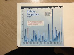
Whilst on the subject of Olympic crossing. Did captain Smith face an icefield on his last crossing with Olympic before Titanic?
Brian Hill and Alan Ruffman did not find any during their research but more recent research may prove otherwise.

However, Edward Smith had however encountered ice on multiple occasions in the vicinity of where the Titanic came to grief.

Hill and Ruffman's paper can be read here:
 
An intertester read of Hill & Ruffman paper. As icefields were no stranger to Smith and him be would wellaway of the dangers.
If had sail on the 20th of March as original plan for maiden crossing, he would have never encountered the icefield.
 

Attachments

  • Iceberg chartI.JPG
    Iceberg chartI.JPG
    845.1 KB · Views: 20
Given the information presented in this thread, RMS Olympic was in position 50°22·0'N 19°17·0'W at 13:17:08 GMT on 16 Jun 1911 (12:00:00 ATS).

On a course of S77°W (257°T) for the next 6h 32m 20s, Olympic would have reached a DR position of 49°52·0'N 22°35·3'W at 19:30:11 GMT (18:13:03 ATS) having made good 133·5 NM at an average of 21·47 knots.

Oops, that should be an afternoon run of 6h 13m 03s.

From 49°52·0'N 22°35·3'W at 19:30:11 GMT, on a course of S74°W (254°T), Olympic would have reached a subsequent DR position of 49°15·2'N 25°52·8'W at 01:43:14 GMT having made good 133·5 NM at an average of 21·47 knots.

At this point, Olympic's ATS would be set back by 52 minutes 12 seconds from 00:26:06 to 23:33:54 to align with ship's solar noon on 17 Jun 1911.

Setting a course of S71¾°W (251¾°T), Olympic would continue through the short period of darkness before sunrise and then onward to a DR position of 48°33·4'N 29°05·2'W at 07:56:17 GMT (05:46:57 ATS for 17 Jun) having made good 133·5 NM at an average of 21·47 knots.
 
This reconstructed RMS Olympic's morning run on 17 Jun 1911 would have continued on a course of S69°W (249°T) to reach a DR position of 47°45·5'N 32°24·7'W at 14:09:20 GMT (12:00:00 ATS) having made good 133·5 NM at an average of 21·47 knots.

This compares to the actual position in the log of 47°51·0'N 32°20·0'W, about 6 NM back to the NE. This could be due to the general set of the Gulf Stream current over those 25 hours.
 
Back
Top